The group of Late Neolithic henge monuments at Knowlton is generally recognised as one of the five most important enclosure complexes in Wessex at this time (Renfrew 1973; Wainwright 1989). These complexes consist primarily of massive earthwork enclosures up to 480m across, and often associated with other Late Neolithic monuments such as timber circles and monumental mounds. The importance of these complexes is demonstrated by their continued role in the Early Bronze Age when they became the focus for round barrow cemeteries. Nonetheless, despite their obvious significance, their function remains poorly understood.
Their role as the effective centres of Wessex have been stressed by several authors (Bradley and Chapman 1986; Wainwright 1989, 147), whilst it has also been noted that they may have acted in the maintenance of relations with other distant communities via the axe trade (Bradley 1984, 54). In terms of the activities which occurred within the henge enclosures, Burgess (1980, 326) argues that the Wessex henges may have held a permanent population of holy men or retainers to a chief. This view is supported by Mackie (1981) who goes a stage further by suggesting that we should compare the large henges of Wessex as being similar to Early Christian monastic sites, combining a ritual role with the domestic life of a resident population. The idea of both a domestic and a ritual role to henge enclosures appears to be supported by the evidence recovered from excavation at Durrington Walls, although the excavators were more cautious in their interpretations (Wainwright and Longworth 1971).
The potential for display at henge sites is also a popular theme in the interpretation of their function. This is a corollary of their design which places the bank outside the ditch thereby creating a grandstand effect from which audiences could view activities taking place in the centre (Burgess 1980, 237). If this is the case we could therefore argue that the role of the ditch was to act as a physical barrier between the observers and the observed, allowing a view, but not access. The suitability of henges to this role is amply shown by the Roman conversion of the henge of Maumbury Rings, Dorchester, into an amphitheatre. Nonetheless, we cannot assume that since we can see the value of henges as auditoriums that their builders held similar views. In this respect it should be noted that at Mount Pleasant the site was, for a time, surrounded by a timber palisade, which would have obstructed both visibility and access to the interior from the banks (Wainwright 1979). With such equivocal evidence, perhaps we should take the view of Darvill (1987, 81-2) that it is likely that henges fulfilled many functions, and indeed changed their role through time.
Extensive fieldwork has been carried out at and around four of these henge enclosures: Avebury (Smith 1965; Ucko et al 1991), Stonehenge and Durrington Walls (Wainwright and Longworth 1971; Richards 1990; Cleal et al 1995); Mount Pleasant (Wainwright 1979), and Marden (Wainwright 1971). At Knowlton however, little or no fieldwork has been carried out and, when this latter complex is mentioned in discussions of henge monuments, it is usually considered by analogy with these better known sites. The extent to which these analogies are accurate is unclear, and can only be resolved by considerable fieldwork in this little understood part of Wessex.
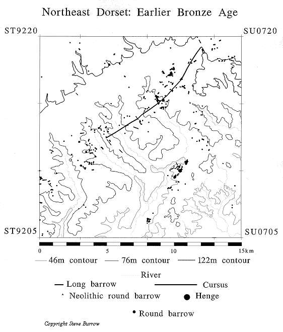
At first sight the lack of fieldwork at Knowlton is curious since just 500m to the north lies Cranborne Chase, where there has been considerable work in recent years in the examination of Neolithic landscape patterns (see Barrett et al 1991; Tilley 1994). These studies have demonstrated the importance of Cranborne Chase in the Early Neolithic, with the long barrows and the Dorset cursus forming obvious focal points for activity. Nonetheless, it seems equally clear that in the Later Neolithic, the local communities ceased building major monuments in Cranborne Chase and diverted their attention to the construction of the henge complex at Knowlton, just to the south (see area plan). That this geographical shift has been so little studied can be explained by examining the history of research in this part of Dorset.
Cranborne Chase is well known as the proving ground for the modern approach to archaeological fieldwork pioneered by General Pitt Rivers in the late 19th century (Barker 1977, 13). His excavations in the area included many famous sites such as Wor Barrow, South Lodge, and the Martin Down enclosure (Pitt Rivers 1898). Unfortunately for the study of British prehistory, the extent of the General's lands ended at the boundaries of Cranborne Chase, and Knowlton lay just outside of this area. The legacy of Pitt-Rivers' fieldwork appears to have acted as a magnet for archaeologists whose new research could refer back to the wealth of evidence he collected. As this level of data for the Neolithic of Cranborne Chase has increased, it seems to have become increasingly difficult to fit the relatively unknown complex at Knowlton into the picture. It is certainly apparent that it will be many years before the quantity of data concerning this latter area compares with that currently available in Cranborne Chase.
In order to make some first steps in rectifying this imbalance Bournemouth University has begun a series of free-standing projects at the Knowlton complex aiming to enhance the general level of knowledge in the area. Through this program of targeted research it is hoped to examine all of the major monuments in the immediate area through detailed survey and small excavation projects. This work will provide a framework, both for the interpretation of the role and extent of the Knowlton complex within the Allen valley, and also its relationship to the wider landscape of Cranborne Chase.
What follows is a more detailed background section introducing the archaeology of the Knowlton area, followed by interim notes on work undertaken to date, and future projects already timetabled.