
Handley Down enclosure, Sixpenny Handley (SU00351657)
The rectangular enclosure on Handley Down has been known from aerial photographs for some time, and has been tentatively identified as a mortuary enclosure by Richard Bradley (Barrett et al 1991, figure 2.8). Nonetheless,no ground investigation has been carried out at the site, despite the strong history of research within the immediate area, which includes work at such sites as Wor Barrow, c.1.2km to the northeast (Pitt Rivers 1898), the Dorset cursus and Wyke Down henge, both c.1.5km to the southeast (Barrett et al 1984). In addition, c.1.5km to the west of the site there are Banjo enclosures, whilst to the east is a concentration of Iron Age settlement remains on Oakley Down.
Magnetometry survey
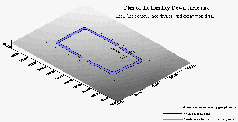
Survey work was conducted at the site in December 1995 using an FM36 Fluxgate gradiometer. Since no auto-logger was available at the time, the sample interval was set to 1 x 1m in order to maximise the area which could be surveyed in the limited time available. The technique showed up the enclosure very clearly with the magnetometer results recording a clearly defined rectangular enclosure with opposing entrances on the longsides. The eastern side of the enclosure bows out slightly around the entrance way. (Following the purchase of an auto-logger, a portion of the survey area was re-examined at an interval of 1 x 0.25m with no additional gain in detail on the resulting plot).
Contour survey
Following the harvesting of crop in late August an excavation was conducted in order to retrieve dating evidence from the monument. As a preliminary to this a contour survey was carried out over the site using a SET4C Sokkia total station. The results of this are incorporated into the site plan.
Excavation
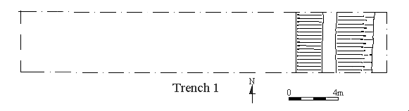
The ground intervention work consisted of two trenches shown on the site plan. Trench 1 was located over a section of ditch on the eastern side of the enclosure and extended into the site's interior. Trench 2 was situated within the enclosure interior close to the eastern entrance. It was hoped that this trench would located features tentatively identified on the magnetometry results as fanning out from this area. In the event trench 2 failed to locate any archaeology. The portion of trench 1 which extended into the interior of the monument also failed to locate any features, or bank remains.
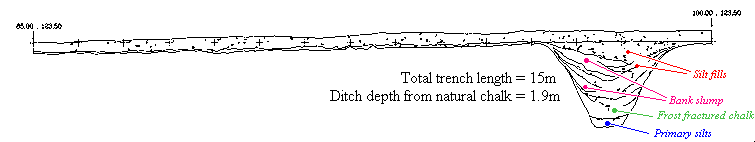
The ditch of the enclosure was found to be 1.9m deep (from the natural chalk surface) with a width at the surface of 3.2m and a basal width of 0.7m (see section and plan); the sides had a uniform gradient. The base of the ditch was filled with a silt deposit into which frost fractured chalk from the ditch sides had subsequently slumped. The basal layer contained a small number of flint flakes, as well as a quantity of charcoal sealed behind an overhang at the ditch base. This was followed by a well-defined slump from a bank on the interior of the monument, interspersed with occasional soil lenses. It is estimated that much of this bank erosion could date to the first fifty years following the excavation of the site (Mike Allen pers comm. 1996).
A number of small animal bones were found in these chalk fills along with a single unweathered sherd of pottery identified as probably Early Neolithic by Richard Bradley and Martin Green (pers comm. 1996). This sherd bears a resemblance to fine wares from the base of the ditch at Wor Barrow, 1.2km to the northeast (Ros Cleal pers comm. 1996).
Silts began to wash into the ditch from the exterior of the enclosure,
during the final stages of the bank slump. Some of this percolated down
into the loose chalk rubble before consolidating as a layer which filled
the remaining ditch depression. At the base of this silting a quantity
of animal bones were found including much of the disarticulated skeleton
of a dog, sheep/goat, and antler.
Discussion
The pottery found at the site provides strong evidence that the monument dates to the Early Neolithic, and it is hoped that radiocarbon dating will place the site more accurately within this period. Even with the coarse dating evidence currently available, the site forms a valuable addition to the corpus of Neolithic monuments in the area, and will hopefully serve to indicate that this period's legacy consists of more than long barrows and the Dorset cursus. Nonetheless, the question of function at the site remains to be addressed. The limited ground intervention carried out to date was not designed to explore this issue, whilst the 2% of the interior excavated provides little hope that the question will be answered by surviving pits or post holes. It seems likely that the best chance of determining the function of the site is to be found in the ditch, presumably around the entrance terminals, although the general sparsity of finds means that a larger section would need to be excavated. At present, all that can be said is that the site has presented no evidence of a mortuary function with which to place it in the amorphous category of 'mortuary enclosure'.
Bibliography
Barrett, J.C., Bradley, R., and Green, M. 1991 Landscape, Monuments and Society: The prehistory of Cranborne Chase. Cambridge: University Press.
Pitt-Rivers, A.L.F. 1898 Excavations in Cranborne Chase, vol IV. Privately Printed
![]() Return
to introduction
Return
to introduction
![]() Back
to research at Whitey Top Farm, Pentridge
Back
to research at Whitey Top Farm, Pentridge
![]() Forward
to research at Manor Farm, Pentridge
Forward
to research at Manor Farm, Pentridge
This page is maintained by Steve Burrow, for further information contact sburrow@bournemouth.ac.uk