|
|
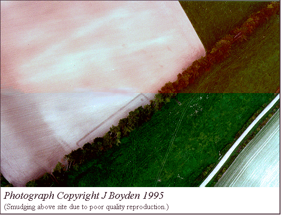
| Photograph showing the location of enclosure (marked in
green) taken from the hillfort on Penbury Knoll. The Dorset cursus runs along the hills behind the site. |
Manor Farm, Pentridge (SU03751865)
Following the success of the survey at Whitey Top Farm
mortuary enclosure it was decided to examine a site which, although bisected
by a treeline, appeared on aerial photographs,
to be morphologically similar. In this instance with a pit at the northern end.
The site is located near the base of a dry valley which floods during winter.
To the south it is overlooked by Penbury Knoll which in turn is topped
by an Iron Age hillfort; to the north the site is flanked by the Dorset
cursus.
|
|
| Photograph showing the location of enclosure (marked in
green) taken from the hillfort on Penbury Knoll. The Dorset cursus runs along the hills behind the site. |
Throughout this report the field in which the site initially showed on
aerial photographs is termed the northern field, whilst the field into
which the site was subsequently found to extend is known as the southern
field.
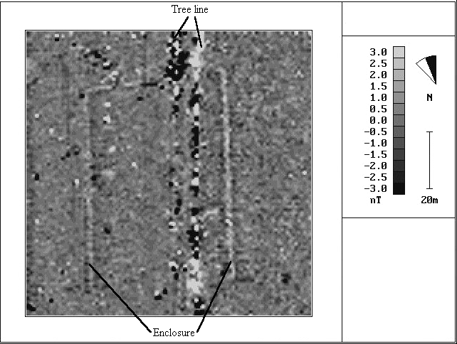
First magnetometry survey
An initial magnetometry survey was carried out over the site in
two phases. The first survey was carried out in December 1995 within the
northern field. Following negotiations with the landowner the magnetometry
survey was extended into the southern field which was under pasture.
The survey was carried out using an FM36 Fluxgate Gradiometer with a sample
interval of 1 x 1m being used since no auto-logger was available. The results
of this survey showed the enclosure extending for some 40m into the pasture
field making an offset playing card shape. This shape argued against the initially
suggested Neolithic date, whilst the form and location of the site near the
base of a valley suggested that it might belong to the Bronze Age (see Toms
1912 for a discussion of the date of similar sites in Dorset).
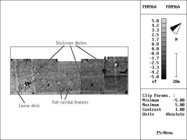
Second magnetometry survey
Given the indeterminate date of the site it was decided to carry out
an excavation over the site in July 1996 and immediately prior to this a further
magnetometry survey was carried out over the southern field in order to
locate more accurately the short sides of the enclosure. In this instance the
survey parameters were 0.5 x 1m and the orientation of survey was changed from
east-west to north-south. The short sides of the enclosure were located by this
second survey although an area of burning and rubbish disposal obscured part
of its length on the western side. It was not possible to survey the northern
field again since this had been laid down to crop. In addition to the side ditches
the new survey also located two sub-circular features in the interior of the
enclosure of c.4m diameter, as well as a linear ditch apparently running
parallel with the western enclosure ditch. With hindsight this feature is also
apparent on the aerial photograph and is visible
across the northern field during ploughing (David pers comm. 1996).
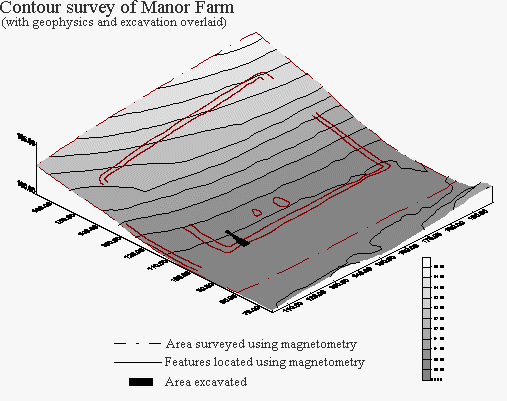
Contour survey
As a further preliminary to excavation a contour survey was also
carried out over the southern field using a SET4C Sokkia total station.
The northern field was surveyed in September 1996 following the harvesting
of the crop.
Excavation
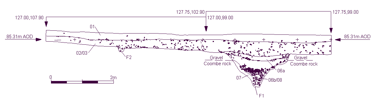
In July 1996 a single trench was placed over the ditch of the enclosure
and extended into its interior. The aim of the excavation was to retrieve artefacts
or carbon samples in order to date the site. The location of the excavation
in relation to the geophysical and contour survey results is shown in the site
plan.
The enclosure ditch was found to have been cut through a shallow flint pebble layer which overlay coombe rock. This pebble layer had a depth of c.0.30m at the southern end of the trench decreasing northwards to c.0.05m in places. This was in turn sealed by c.0.70m of silts (contexts 01, 02, 03). It therefore seems possible that much of the interior of the enclosure, if still surviving, has been effectively sealed from future damage. In this respect it is also worth noting that the farmer, Mr David, remembers the southern field as being in pasture for at least 50 years.
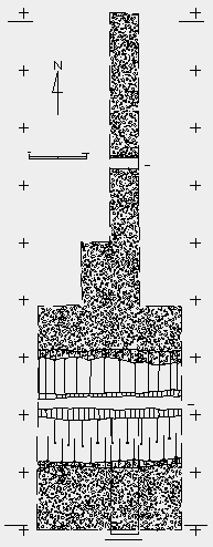
The ditch was found to be 1m deep with a width of 2m where it cut the gravel
see trench plan. The profile
of the ditch was regular, ending in a slot trench at the base. The basal
fills (context 07) consisted of a mix of silts with chalk and some flint pebbles,
the latter being washed from the pebble layer above. Context 07 was sealed by
a silty layer which formed the majority of the ditch fills and showed little
evidence of stratigraphy. The lower part of this fill was, however, differentiated
by a quantity of large flint nodules (context 08). It seems likely that these
were deliberately added, possibly to act as a field drain to channel the upper
reaches of the River Crane which floods in winter and would doubtless have utilised
the enclosure ditch for part of its course, thereby adding to the ditch fills.
The upper portion of the ditch fills appeared uniform during excavation (context
06), however, a buried soil was identified in section (context 06a) on the basis
of ped structure by Mike Allen, Wessex Archaeology.
No bank remains were found within the section excavated, although a
small shallow gully was located (F2). Unfortunately, the trench was too
narrow at this point to comment effectively on this feature.
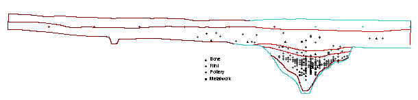
The finds from the excavation were considerable given the small area excavated (less than 1% of the enclosure perimeter). Very few finds were found above the gravel layer, although there was a quantity of burnt flint distributed evenly throughout all the contexts on the site. The quantity of finds increased within the upper fills of the ditch, but the majority were located just above the stones of context 08 (see finds distribution plot). Analysis has not yet been carried out on the finds, although they are late Romano-British in character. They include several concentrations of hob nails, c.400 sherds of pottery (mostly unabraded sherds) including a few Samian pieces, and a quantity of animal bone; shellfish were also found, including oyster.
Conclusion
The enclosure is clearly Romano-British, and it is to be hoped that
following analysis of the ceramics a more precise date will be achieved
for the rubbish deposits on the site. It is unfortunate that no diagnostic
finds were recovered from the base of the ditch, although it seems likely
that the silts could have reached the level of the major finds distribution
within 30 - 50 years of the site's construction (Mike Allen pers comm.1996).
There therefore seems little reason to believe that the site was constructed
prior to the Romano-British period. Turning to the ditch itself, the broad
shape of the cut, and the presence of a slot trench at the base can all
be paralleled at other Romano-British sites in the vicinity, eg, the settlements
at Woodcuts and Rotherley (Pitt Rivers 1887, 1888). In this respect, the
'square enclosure' at Bokerley Dyke (Pitt Rivers 1892) is of particular
interest since it provides a parallel for the form of the Manor Farm enclosure,
albeit on a smaller scale. In the case of the square enclosure, despite
total excavation little was recovered from the interior of the site other
than 5 inhumations.
Given that excavation was limited to the ditch it is clearly inappropriate to comment on the function of the site, although the large quantity of unabraded finds recovered suggest, however, that the site was permanently occupied. In addition, the apparent association between the enclosure and a nearby linear ditch suggests that the site formed part of a much larger landscape articulation.
Bibliography
Pitt-Rivers, A.L.F. 1887 Excavations in Cranborne Chase, vol I. Privately Printed.
Pitt-Rivers, A.L.F. 1888 Excavations in Cranborne Chase, vol II. Privately Printed.
Pitt-Rivers, A.L.F. 1892 Excavations in Cranborne Chase, vol III. Privately Printed.
Toms, H. 1912 Notes on some surveys of valley entrenchments in the Piddletrenthide District, Central Dorset. Proceedings of the Dorset Natural History and Archaeological Society 33, 34-44.
![]() Return
to introduction
Return
to introduction
![]() Back
to research at the Handley Down enclosure, Sixpenny Handley
Back
to research at the Handley Down enclosure, Sixpenny Handley
![]() Forward
to research at Goldfields Farm, Sixpenny Handley
Forward
to research at Goldfields Farm, Sixpenny Handley
This page is maintained by Steve Burrow, for further information contact sburrow@bournemouth.ac.uk
