![]() Return
to introduction
Return
to introduction
![]() Back
to research at Manor Farm, Pentridge
Back
to research at Manor Farm, Pentridge
![]() Forward
to research at Down Farm, Gussage St Michael
Forward
to research at Down Farm, Gussage St Michael
Goldfields Farm, Sixpenny Handley (ST968137)
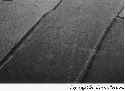
The site at Goldfields Farm was the last site to be surveyed in this series of investigations, it also happened to be the most extensive. The aerial photograph which initially attracted attention to the site appeared to show a ring ditch and a rectangular enclosure, clearly defined on three sides, and with an odd kink on one of these. This enclosure seemed to be curving around the ring ditch. In addition, to these features the photograph also showed other ditches, although apparently not in association.
The only previously published comment on the site was by Barrett et al (1991, figure 2.8) who noted the enclosure to be a possible Neolithic mortuary site. The general area of the field is, however, known to have produced Iron Age and Romano-British finds, and during the current phase of work an extensive flint scatter was noted. Following consultation with the landowner in September 1996 it was agreed that a magnetometry survey could be carried out over the field.
At the same time as this work was carried out, just over the hill, c.300m to the northeast, a Romano-British site was being excavated by Chris Spoery-Green. A gradiometry survey was conducted over this R-B site with the permission of the director but without result.
Magnetometry survey
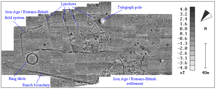
Survey work was conducted at the site in September 1996 using an FM36 Fluxgate
gradiometer. The sample interval was set to 1 x 0.5m, and the survey was conducted
over a four day period covering an area of 2.5ha. The results
show the ring ditch at the north of the site very clearly, as well as the adjacent
enclosure. It now appears that this enclosure is more extensive than was first
thought since it clearly extends for c.200m to the southwest and seems
to be related to a complex of pits and ditches in the centre of the plot. This
complex is highly suggestive of settlement enclosures, probably of Iron Age
or Romano-British date, given the finds from the field. If this is indeed the
case then the enclosure beside the ring ditch is probably a related field system.
Running northeast - southwest along the base of the plot is a linear ditch which is visible within the adjacent field during ploughing and extends for several hundred metres at least. This feature is noted on the results as a ranch boundary. A further ditch can be seen branching away from this boundary and running south into the survey area before butting into a second complex of pits and ditches presumably resulting from settlement. The apparent associations between these two ditches and the second settlement suggests a further and stratigraphically unrelated episode of landscape divsion.
A question which is clearly of interest is: how do the two complexes relate in time? Given that finds of both Iron Age and late Romano-British date have been found at the site it tempting to suggest that the two settlements are temporally distinct. Nonetheless, the possibility that they represent a single and long-lived settlement must still be entertained.
A final point of interest revealed by the survey is the presence of a number of lynchets running east - west along the contours of the hill and apparently sealing at least one of these complexes. Within the area surveyed it is therefore possible to identify as many as four separate phases of activity from the Bronze Age ring ditch through to the establishment of the lynchet field system.
Bibliography
Barrett, J.C., Bradley, R., and Green, M. 1991 Landscape, Monuments and Society: The prehistory of Cranborne Chase. Cambridge: University Press.
![]() Return
to introduction
Return
to introduction
![]() Back
to research at Manor Farm, Pentridge
Back
to research at Manor Farm, Pentridge
![]() Forward
to research at Down Farm, Gussage St Michael
Forward
to research at Down Farm, Gussage St Michael
This page is maintained by Steve Burrow, for further information contact sburrow@bournemouth.ac.uk