Results and Interpretation (summary)


.
 
Full image
Magnetometry 

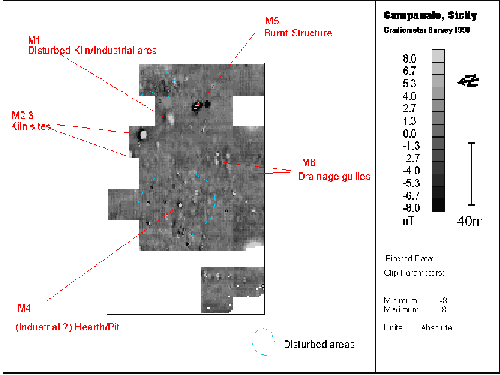
The great majority of the western and north-eastern sectors of the surveyed area display marked and extensive magnetic disturbance not entirely inconsistent with either a settlement area or one that has undergone much disturbance agriculturally. The anomalies marked M1-6  are the principal areas of interest. The most significant anomalies at this stage would appear to be M2 and 3 which recorded such a characteristic thermoremnant signal that immediately suggested a kiln or small furnace. Excavations (Trench F,) subsequently confirmed that the more easterly of these maculae was indeed a kiln. Further to the east a similar anomaly (M1) may be associated with industrial activity, it's form however is much more irregular and is difficult to interpret. The intense burning in the location of Trench E was clearly picked up by the magnetometer (M5) and would appear to the result of a conflagration which led to the destruction of a fifth century AD building

.
 
Full image
Resistivity 

Initial results from the resistivity survey were extremely (but not entirely without expectation) disappointing. Excavation had shown that the footings for the mud brick structures found on the site were commonly constructed from walls composed of relatively un-coursed stone. It was hoped that these footings would show up as areas of high resistivity on the subsequent survey. This Figure does clearly show tantalising traces of linear high resistivity traces but they are generally obscured. This is probably primarily due to the very dry conditions that were extant at the time of the survey. In addition it cannot be discounted that the intermittent linear anomalies could reflect disturbance through robbing and or later agriculture.   

Many of the linear anomalies are also quite extensive which may suggest that they are not buildings at all but perhaps compacted routeways within the settlement area. 


This page has been compiled and is maintained by John Gale jgale@bmth.ac.uk and Jeff Chartrand jchartra@bmth.ac.uk
All data and graphics are copyright to the School of Conservation Sciences, Bournemouth University, 1997, unless otherwise stated.
Last updated 29th July 1997.