|
|
 |
|
|
|
PHASE ONE: THE GIS MODEL
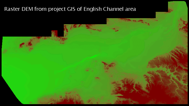
To incorporate the variety of spatial, textual and graphical data considered in this project, a GIS model is being developed using ARC/INFO software. The base is a digital terrain model (DTM) that was constructed from data from six sources (EDX, British Geological Survey, Ordnance Survey, British Admiralty, Institut Géographique National, and GLOBE). These data were converted to the Great Britain National Grid reference system for digitising and GIS construction. A TIN (triangulated irregular network) of available terrain data was constructed and converted to a raster grid for modelling. The raster DEM represents the land surface of the English Channel study area (see figure below); construction was based on surveyed bathymetry and on-shore terrain.
Estimations of the English Channel coastal plain during the Holocene were based on 94 sea-level indicator points from Devoy (1982, tables 3-4). Long and Tooley (1995, 305) refer to 57 radiocarbon dated transgressive and regressive contacts recorded since Devoys (1982) work. These contacts were located between the Thames Estuary and Stansore Point; however, it has not been possible to use this more recently collected data at this stage. The first stage plotting of the Devoy data (age in radiocarbon years and height relative to Ordnance Datum) produced an initial time-depth curve.
REFERENCESDevoy R J, 1982. Analysis of the geological evidence for Holocene sea-level movements in southeast England. Proceedings of the Geologists Association 93, 65-90Much of the text of this page is derived from the draft paper prepared by Dr R Hosfield during Phase One of this project.Long A J & M J Tooley, 1995. Holocene sea-level and crustal movements in Hampshire and Southeast England, United Kingdom. Journal of Coastal Research (Special Issue No. 17: Holocene Cycles: Climate, Sea Levels, and Sedimentation), 299-310
GO TO:
Comments and enquires should be addressed to Dave Parham
Early History of the English Channel Project
School of Conservation Sciences, Bournemouth University, Talbot Campus, Poole, Dorset, BH12 5BB, UK
This page was compiled by Eileen Wilkes and is maintained by Dave Parham, School of Conservation Sciences, Bournemouth University. Last Updated February 2003
All images are copyright Bournemouth University unless otherwise stated.